
Furka Pass and Grimsel Pass to Aletsch Glacier – a perfect day in Swiss Alps!


If you have just few days to visit Switzerland, it is extremely difficult to choose only several places worth sightseeing. Obviously, our bucket list always includes some mountains that are at the top positions. Ironically, the term ‘mountains’ seems to be the bottomless pit. In this tiny country are 437 peaks – the average elevation is above 3 000 metres above the sea level. So what should we pick? We have decided to see something that is between the mountains – the largest glacier in the Alps – the Aletsch Glacier. And if you mention here the story about agent 007 – it will be a marvellous one-day trip!
")
We rented a car for that trip. Contrary to what one can believe, renting a car is much cheaper than travelling by train. Moreover, a car provides you with a feeling of a total freedom while sightseeing which we really love and appreciate. Instead of a compact car, which we had ordered at Zurich Airport (it was the cheapest place), we were given a decent family car (Ford Galaxy – in spite of having a liking for that car, we would have never changed it with our Škoda) that was able to manage with winding roads. However, it was too big for steep inclines and declines as well as for doing a 180-degree turn and as a result it spoiled our fun. By the way, we chose the most extreme route to the glacier from those available in Switzerland.
")


Furka Pass
The most beautiful scenic route in Switzerland
Furka pass is a mountain pass which connects the cantons of Valais and Uri. It is located at around 2 200 metres above the sea level with its highest point at 2 429 metres above the sea level. The length of the road is 22.5 km (from Realp to Gletsch). The distance in a straight line drawn on a map is only 12 km. Snow-clad hard shoulders, grazing cows and a scenery of meadows mixed with rocky summits cannot allow us to stay in a car.
")

")


")
Due to the popularity of the route, the traffic is quite heavy. As it was mentioned in the beginning of the post, the great fame of this place has been achieved because of double zero and seven that represent the agent of Her Majesty. Here some chase scenes with James Bond played by Sean Connery took place. In the movie Goldfinger his Aston Martin races through those serpentine roads. Of course, we had a possibility to see two of those cars but none of them had British plates.


Sempervivum montanum
Sempervivum montanum is an example of a plant which appears only in the Tatra Mountains, Babia Góra National Park and in some parts of Bieszczady Mountains. But here it is so popular that it can be found almost next to every third stone. It is fascinating that indigenous people of the Alps believed that its flowers could protect from lightning so it was common to plant it on the roofs of their houses.


")
Aletsch Glacier
To the top of the Eggishorn and down
We reached Fiesch from Furka pass. We used a cable car which takes tourists who would like to get to the Eggishorn (the single ticket to the top costs 45 CHF). The distance to the intermediate station is 1 500 metres. After buying our tickets we entered the cable car and then we went up to the top. After several minutes we were supposed to change the cabin which ran to the top.
")
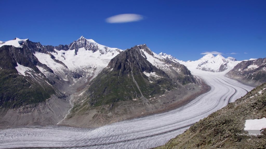
When we left the cabin the weather was fantastic. The sky was so clear and cloudless that the Matterhorn was visible. We were around 300 metres easy walk from the top of the Eggishorn (the elevation of the summit is 2 934 metres above the sea level). One can have an impression that beneath their feet they have the curved Aletsch glacier which is 23 kilometres long and almost one kilometre thick. From that perspective it looks like white multiple lane motorway which fulfils some space between rocky summits.
")
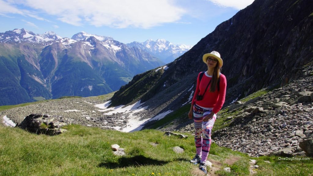
Fortunately, there are only very few people so we relished our freedom. In order not to waste time, we immediately decided to go to the peak since 300 metres of a stony path was to climb.

At the peak, which looks like an artificial mountain made of stones, we had a break to rest in the sunlight. It was so warm that long-sleeved clothes were not necessary. A feeling of peace was indescribable. From time to time only some voices of people coming up and down disturbed complete silence. We allowed ourselves to take some pictures and to recharge our batteries since we had to make long descent.


")
From the top, it is possible to admire not only the glacier but also the skyline of a valley and some nearby summits. The Eiger seems to be at hand, whereas the Matterhorn is somewhere far away. The sky was almost clear, only with some fluffy clouds and thanks to a telephoto lens some particular stones on the nearby mountains could be noticeable.
")


UNESCO World Heritage high trail
There is a high trail from Eggishorn to Bettmerhorn which is inscribed on the World Heritage list. According to the guidebook and some trail descriptions it is well-secured but also extremely demanding. The trail is 2.3 km long and it takes 3 hours. The route leads through summits (see the picture). It was a pity that we didn’t have enough time.
")
At the beginning the descent was steep. However, after one kilometre we reached a mountain pass and then we were heading towards ski slopes. From time to time we were walking in the grass, then between some stones and occasionally we were slipping through snow.


We were lucky to observe several fat and fluffy marmots which ran between the stones.
")
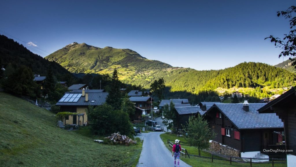
The trail transformed rapidly into a wide path leading to the intermediate station of the cable car. From that point we were going to Fiesch – passing through pastures on which the cows were grazing. The further we went, the route became wilder. Finally, the way changed into a narrow and steep path surrounded by trees.

It took a quarter to go along Fiesch. The descent from the Eggishorn is 12 km long and the difference of height is 1 800 metres. We needed four and a half an hour to complete it. Wearing smiles on our faces we were fully satisfied but, of course, also tired and it was high time to come back.
")

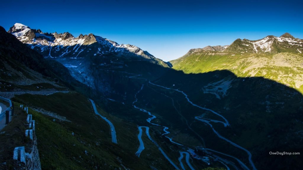
The Grimsel Pass
Our way back led through the Grimsel Pass which is an area next to the Furka Pass. It is as beautiful as the previous one with picturesque views that we admired in the sunset. The desire to take some more pictures was deep but the temperature of only 7 Celsius degrees as well as icy wind discouraged us from putting up the tripod and setting exposure in a camera. It was simply too cold and it was time to come back.

")


Leave A Comment
You must be logged in to post a comment.


One Comment
Fantastic photo journal, thank you! My family and I took a wrong turn and were in this area due to road work (and our wrong turn). We drove for hours!!! (Which, was kind of fun and we had gas so we kept going…) The leg stretch was at the Hotel Glacier du Rhone at Gletsch. We did not know what we were in for – and, to be honest- I’m trying to remember which pass we did drive over. Beautiful views though and I long for a time to revisit with my fav hiking partner. Wow!